Gym nearby Lainchour Byam Mandir
Nepal
Gym nearby Lainchour Byam Mandir
Lainchour Byam Mandir
Katmandú 44600, Nepal
contacts phone
:
+977
Latitude:
27.7183556
, Longitude:
85.3152014
larger map & directions
read more
nearest Gym
32 m
सामुदायिक शहरी स्वास्थ्य क्लिनिक
लैनचौर मार्ग, Kathmandu
Gym
read more
281 m
GAA GYM
Kathmandu
Gym
read more
286 m
GAA hall
Kathmandu
Gym
read more
431 m
Chetana Yoga Foundation
Chaksibari Marg, Kathmandu
Gym
read more
441 m
Rising Fitness Centre
44600, काठमाडौँ
Gym
read more
486 m
Pranamaya Thamel Yoga Studio
Top floor of Himalayan Java (Tridevi Marg branch), काठमाडौँ
Gym
read more
498 m
Priority Yoga Training Center
Thamel Marg, Kathmandu
Gym
read more
588 m
SHYAAM G YOGA
Chaksibari Marg, Kathmandu
Gym
read more
595 m
निरोगी योग ध्यान शिविर
थापखिया मार्ग, Kathmandu
Gym
read more
600 m
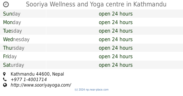
Sooriya Wellness and Yoga centre
Kathmandu
Gym
read more
631 m
Om Singing Bowls And Healing Hub
Z Street, Kathmandu
Gym
read more
798 m
LAZIMPAT JYM
नील सरस्वती मार्ग, काठमाडौँ
Gym
read more
856 m
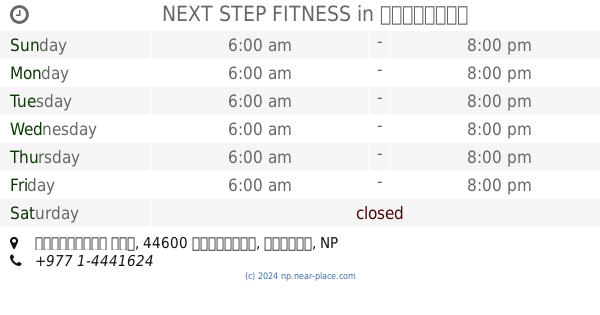
NEXT STEP FITNESS
लाजिम्पाट रोड, काठमाडौँ
Gym
read more
945 m
Thyrocare
Narayanhiti Path, Kathmandu
Gym
read more
948 m
Barhmakumari Yoga sub-service kendr
श्री मार्ग, काठमाडौँ
Gym
read more
1.17 km
Central Fitness
Kathmandu
Gym
read more
1.177 km
The Physique Workshop
Kathmandu
Gym
read more
1.221 km
CITY HEALTH CLUB
Pashupati Road, Kathmandu
Gym
read more
1.421 km
Subhalaxmi Complex
Samakhushi - Ranibari Road, Kathmandu
Gym
read more
1.461 km
Kathmandu Fitness Club
Kamal Marg, Kathmandu
Gym
read more
1.527 km
New Mumbai Training Center
44600, Kathmandu
Gym
read more
1.644 km
NAVAJEEVAN YOGASHRAM
Pashupati Road, Kathmandu
Gym
read more
1.713 km
भगवती मानव कल्याण संगठन
भग्वती मार्ग, काठमाडौँ
Gym
read more
1.911 km
Himal Gym
Kathmandu
Gym
read more
1.977 km
Gold's Fitness
Bishal Nagar Marg, Kathmandu
Gym
read more
📑
all categories
Accounting
Administrative area level 1
Administrative area level 2
Airport
Amusement park
Aquarium
Art gallery
Atm
Bakery
Bank
Bar
Beauty salon
Bicycle store
Book store
Bowling alley
Bus station
Cafe
Campground
Car dealer
Car rental
Car repair
Car wash
Casino
Cemetery
Church
City hall
Clothing store
Colloquial area
Convenience store
Courthouse
Dentist
Department store
Doctor
Electrician
Electronics store
Embassy
Establishment
Finance
Fire station
Florist
Food
Funeral home
Furniture store
Gas station
General contractor
Grocery or supermarket
Gym
Hair care
Hardware store
Health
Hindu Temple
Home goods store
Hospital
Insurance agency
Jewelry store
Laundry
Lawyer
Library
Liquor store
Local government office
Locality
Locksmith
Lodging
Meal delivery
Meal takeaway
Mosque
Movie rental
Movie theater
Moving company
Museum
Natural feature
Neighborhood
Night club
Painter
Park
Parking
Pet store
Pharmacy
Physiotherapist
Place of worship
Plumber
Point of interest
Police
Post office
Premise
Real estate agency
Restaurant
Route
Rv park, camping
School
Shoe store
Shopping mall
Spa
Stadium
Storage
Store
Subpremise
Supermarket
Synagogue
Taxi stand
Train station
Transit station
Travel agency
University
Veterinary care
Zoo
administrative area level 3
sublocality level 1
↑