School nearby Vidhya Sadan Secondary School, New Building
Nepal
School nearby Vidhya Sadan Secondary School, New Building
Vidhya Sadan Secondary School, New Building
Birgunj 44300, Nepal
contacts phone
:
+977 51-528997
Latitude:
27.0216942
, Longitude:
84.8862387
larger map & directions
read more
nearest School
176 m
Vidhya Sadan Sec. School
H O2, Murli Pokhari, Birgunj-15, Parsa (Nepal), Birgunj
School
read more
199 m
Siddhartha International College Birgunj...
Birgunj
School
read more
224 m
Royal Academy
Birgunj
School
read more
281 m
Shree Surajidevi Secondary School
Birgunj
School
read more
381 m
Matrix College Of Pharmacy
Birgunj
School
read more
422 m
Miniland English Boarding School
Birgunj
School
read more
735 m
Gyan Vatika Higher Secondary School
Shreepur, Ranighat Road 14, Birgunj
School
read more
895 m
Google Computer And Advanced Coaching Center
Birgunj
School
read more
1.105 km
GHP Secondary School
Birgunj - 16, Shreepur, त्रिभुवन राजपथ, Birgunj
School
read more
1.313 km
Shree Siddhartha Higher Secondary School
Birgunj
School
read more
1.324 km
Siddhartha Higher Secondary School
Birgunj
School
read more
1.325 km
Mr. Siddharth High in B
Birgunj
School
read more
1.556 km
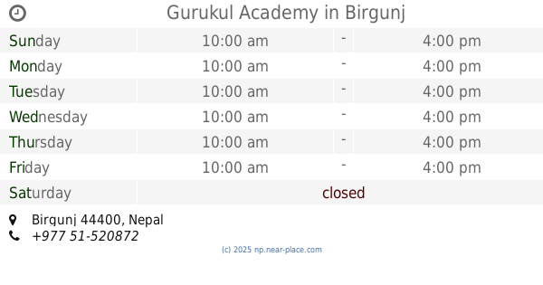
Gurukul Academy
Birgunj
School
read more
1.791 km
Ramgadhwa School
Ramgarhwa - Adapur Road, Birgunj
School
read more
2.054 km
Gyanda Academy
Nepal
School
read more
2.128 km
Pashupati Siksha Mandir
Birgunj
School
read more
2.382 km
Mount Hermon School
Birgunj
School
read more
2.961 km
Shree Sharda Higher Secondary School
Birgunj
School
read more
3.195 km
gautam sec school
Birgunj
School
read more
3.195 km
Moonlight English Boarding School
05 Birgunj, Resham Kothi, Birgunj
School
read more
3.858 km
Gurukul Panna English Boarding School Athraha Sugauli
Athraha Sugauli, Birgunj
School
read more
5.463 km
Bahai Balniketan Primary School.
44300, बीरगञ्ज
School
read more
📑
all categories
Accounting
Administrative area level 1
Administrative area level 2
Airport
Amusement park
Aquarium
Art gallery
Atm
Bakery
Bank
Bar
Beauty salon
Bicycle store
Book store
Bowling alley
Bus station
Cafe
Campground
Car dealer
Car rental
Car repair
Car wash
Casino
Cemetery
Church
City hall
Clothing store
Colloquial area
Convenience store
Courthouse
Dentist
Department store
Doctor
Electrician
Electronics store
Embassy
Establishment
Finance
Fire station
Florist
Food
Funeral home
Furniture store
Gas station
General contractor
Grocery or supermarket
Gym
Hair care
Hardware store
Health
Hindu Temple
Home goods store
Hospital
Insurance agency
Jewelry store
Laundry
Lawyer
Library
Liquor store
Local government office
Locality
Locksmith
Lodging
Meal delivery
Meal takeaway
Mosque
Movie rental
Movie theater
Moving company
Museum
Natural feature
Neighborhood
Night club
Painter
Park
Parking
Pet store
Pharmacy
Physiotherapist
Place of worship
Plumber
Point of interest
Police
Post office
Premise
Real estate agency
Restaurant
Route
Rv park, camping
School
Shoe store
Shopping mall
Spa
Stadium
Storage
Store
Subpremise
Supermarket
Synagogue
Taxi stand
Train station
Transit station
Travel agency
University
Veterinary care
Zoo
administrative area level 3
sublocality level 1
↑